Maps
St. Louis in 1870
The
Central West End in 1875
The
Central West End in 1890
St. Louis in 1897-1901 Caution! 148MB
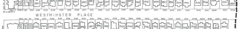
Our
neighborhood in 1897
Our
neighborhood in 1909 - northwest quadrant (Sanborn Maps sheet 083)
Our
neighborhood in 1909 - northeast quadrant (Sanborn Maps sheet 084)
Our
neighborhood in 1909 - southwest quadrant (Sanborn Maps sheet 095)
Our
neighborhood in 1909 - southeast quadrant (Sanborn Maps sheet 096)
Our
neighborhood in 1909 - nearby streets (Sanborn Maps index)
Forest
Park with World's Fair overlay
- as a Google
Earth KMZ file
CWE buildings 1928 and earlier
- east of Kingshighway
CWE buildings 1928 and earlier
- west of Kingshighway
Plat
map from about 1930 - clipped from above
Map
of our neighborhood
Satellite
photo of our neighborhood
As
above but very detailed
- caution! 951 KB
Satellite photo - newer, higher resolution and in color
Buried street light wiring - map
Map
of Forest Park
Weather forecast
- with 10-day prediction